目录
二、依赖包的下载(echarts、echarts-gl、jQuery)
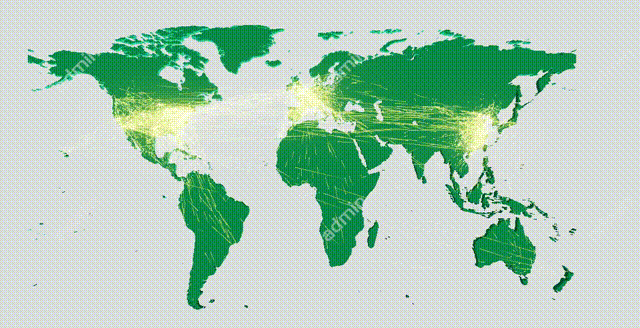
一、案例效果图
二、依赖包的下载(echarts、echarts-gl、jQuery)
如下是 ECharts 官网给出的代码,但要注意的是,该代码需要 echarts、echarts-gl、jQuery 的加持才能正常使用;如果不安装依赖包,直接将官网代码引入项目中,会报各种错!

所以我们需要分别在项目中下载安装这些依赖包;
1.echarts 包的下载
(1)通过 npm 安装 ECharts;
npm install echarts --save(2)在 src 下 main.js 中全局引入 Echarts;
import echarts from 'echarts';
Vue.prototype.$echarts = echarts;
(3)已全局引入,单页面中无需再引。
2.echarts-gl 包的下载
(1)注意此处有坑,如果我们直接使用 npm 命令 npm install echarts-gl 下载 echarts-gl 是无法下载的,会报错(名字冲突,拒绝下载),所以我们下载 echarts-gl 的低版本;
npm i [email protected] -S(2)然后,同样在 src 下 main.js 中全局引入 echarts-gl;
import 'echarts-gl'(3)已全局引入,单页面中无需再引。
3.jQuery 包的下载
(1)通过 npm 安装 jQuery;
npm install jquery --save(2)在 src 下 main.js 中引入 jQuery;
import jquery from 'jquery';
Vue.prototype.$ = jquery;
(3)在需要使用到 jQuery 的页面中引入;
import $ from "jquery"
4.小结
npm 下载依赖:
npm install echarts --save;
npm i [email protected] -S;
npm install jquery --save;
main.js 中:
import echarts from 'echarts'
import 'echarts-gl'
import jquery from 'jquery'

Vue.prototype.$ = jquery;
Vue.prototype.$echarts = echarts;
页面文件中:
import $ from "jquery"; //引入jQuery
import 'echarts/map/js/world.js' //必须引入世界地图
注意世界地图必须在页面中引入,否则3d路径图依然无法呈现。
三、完整代码
<template>
  <div class="login_new">
    <div id="main" style="width: 100%;height: 10rem"></div>
  </div>
</template>

<script>
  import * as echarts from 'echarts';
  import 'echarts-gl';
  import $ from "jquery"; //引入jQuery
  import 'echarts/map/js/world.js' //必须引入世界地图

  export default {
    name: "login_new",
    methods: {
      //绘制3D路径图
      draw() {
        var ROOT_PATH = 'https://cdn.jsdelivr.net/gh/apache/echarts-website@asf-site/examples';
        var myChart = this.$echarts.init(document.getElementById('main'));
        var option;

        var uploadedDataURL = ROOT_PATH + '/data-gl/asset/data/flights.json';
        myChart.showLoading();
        $.getJSON(uploadedDataURL, function (data) {
          myChart.hideLoading();

          function getAirportCoord(idx) {
            return [data.airports[idx][3], data.airports[idx][4]];
          }

          var routes = data.routes.map(function (airline) {
            return [getAirportCoord(airline[1]), getAirportCoord(airline[2])];
          });
          myChart.setOption({
            geo3D: {
              map: 'world',
              shading: 'realistic',
              silent: true, //鼠标设置为不触发事件
              environment: '#333', //背景色
              realisticMaterial: {
                roughness: 0.8,
                metalness: 0
              },
              postEffect: {
                enable: true
              },
              groundPlane: {
                show: false
              },
              light: {
                main: {
                  intensity: 1,
                  alpha: 30
                },
                ambient: {
                  intensity: 0
                }
              },
              viewControl: {
                distance: 70, //地图缩放程度
                alpha: 89, //地图翻转程度
                panMouseButton: 'left',
                rotateMouseButton: 'right',

                rotateSensitivity: false,  //地图是否能旋转
                zoomSensitivity: false //地图是否能缩放
              },
              itemStyle: {
                color: '#000' //地图的颜色
              },
              regionHeight: 0.5 //地图高度
            },
            series: [
              {
                type: 'lines3D',
                coordinateSystem: 'geo3D',
                effect: { // 特效线的配置
                  show: true,
                  trailWidth: 1,
                  trailOpacity: 0.5,
                  trailLength: 0.2,
                  constantSpeed: 5 //特效固定速度
                },
                blendMode: 'lighter',
                lineStyle: { //特效线
                  width: 0.2,
                  opacity: 0.05
                },
                data: routes
              }
            ]
          });
          window.addEventListener('keydown', function () {
            myChart.dispatchAction({
              type: 'lines3DToggleEffect',
              seriesIndex: 0
            });
          });
        });
      }
    },
    mounted() {
      this.draw();
    }
  }
</script>

<style scoped>

</style>