1、将高德地图引入项目
第一步:在index.html文件中引入
<script type="text/javascript" src="https://webapi.amap.com/maps?v=1.4.15&key=自己申请的key"></script>
<script src="//webapi.amap.com/ui/1.0/main.js"></script>
第二步:在webpack.base.conf.js的module.exports里添加
externals: {
   'AMap': 'AMap'
 }
第三步:在使用高德地图的组件里使用
<template>
  ...
    <div id="container" class='container'> </div>
  ...
</template>
<script>
import AMap from 'AMap'
export default {
...
}
</script>
2、动态绘制路线
第一部分:创建组件实例
var emptyLineStyle = {
          lineWidth: 0,
          fillStyle: null,
          strokeStyle: null,
          borderStyle: null
 };
var pathSimplifierIns = new PathSimplifier({
        zIndex: 100,
        map: map, //所属的地图实例
        // clickToSelectPath: false,
        getPath: function(pathData, pathIndex) {
          //返回轨迹数据中的节点坐标信息,[AMap.LngLat, AMap.LngLat...] 或者 [[lng|number,lat|number],...]
          return pathData.path;
        },
        getHoverTitle: function(pathData, pathIndex, pointIndex) {
          //返回鼠标悬停时显示的信息
          if (pointIndex >= 0) {
              //鼠标悬停在某个轨迹节点上
              return pathData.name + ',点:' + pointIndex + '/' + pathData.path.length;
          }
          //鼠标悬停在节点之间的连线上
          return pathData.name + ',点数量' + pathData.path.length;
        },
        //仅展示驶过线
        renderOptions: {
            pathLineStyle: emptyLineStyle,
            pathLineSelectedStyle: emptyLineStyle,
            pathLineHoverStyle: emptyLineStyle,
            keyPointStyle: emptyLineStyle,
            startPointStyle: emptyLineStyle,
            endPointStyle: emptyLineStyle,
            keyPointHoverStyle: emptyLineStyle,
            keyPointOnSelectedPathLineStyle: emptyLineStyle,
            //轨迹线的样式(若想显示轨迹线就用下面这种)
            // pathLineStyle: {
            //     strokeStyle: 'blue',
            //     lineWidth: 4,
            //     dirArrowStyle: true
            // }
        }
        //若想显示轨迹线就用下面这种,二者选其一
       // renderOptions: {
            //轨迹线的样式
            // pathLineStyle: {
            //     strokeStyle: 'blue',
            //     lineWidth: 4,
            //     dirArrowStyle: true
            // }
       // }
  });
第二部分: 构建轨迹
pathSimplifierIns.setData([{
     name: '测试',
     path: [
        [119.405289, 41.904987],
        [117.964458, 40.54664],
        [118.47836, 41.135964],
        [118.949297, 41.670904]
     ]
 }]);
第三部分:创建一个巡航器
var navg0 = pathSimplifierIns.createPathNavigator(0, //关联第1条轨迹
          {
              loop: false, //循环播放
              speed: 100000,
              pathNavigatorStyle: {
                  autoRotate: true, //禁止调整方向
                  pathLinePassedStyle: null,
                  width: 24,
                  height: 24,
                  // content: PathSimplifier.Render.Canvas.getImageContent('../../static/blueSpot.png', onload, onerror),
                  strokeStyle: null,
                  fillStyle: null
              },
          });

navg0.start();
第四部分:加载PathSimplifier,启动页面(将第一到第三部分,在methods里封装成一个 initPage() 的方法,在 mounted() 里启动)
AMapUI.load(['ui/misc/PathSimplifier'], function(PathSimplifier) {
  if (!PathSimplifier.supportCanvas) {
        alert('当前环境不支持 Canvas!');
        return;
    }
   //启动页面
   that.initPage(PathSimplifier);
 });
完整代码如下(包含让地图实现高度自适应的方法):
<template>
  <div class="page_hello" :style="{ height: screenHeight + 'px' }">
    <div id="container" class='container'>

    </div>
  </div>
</template>
<script>
import AMap from 'AMap'
export default {
  name: 'Home',
  data () {
    return {
      screenHeight: document.documentElement.clientHeight
    }
  },
  mounted() {
    const that = this;
    window.onresize = () => {
      return (() => {
         window.screenHeight = document.documentElement.clientHeight
         that.screenHeight = window.screenHeight
      })()
    };
    //加载PathSimplifier,loadUI的路径参数为模块名中 'ui/' 之后的部分
    AMapUI.load(['ui/misc/PathSimplifier'], function(PathSimplifier) {
        if (!PathSimplifier.supportCanvas) {
            alert('当前环境不支持 Canvas!');
            return;
        }
        console.log(PathSimplifier)
        //启动页面
        that.initPage(PathSimplifier);
    });
  },
  watch: {
    screenHeight (val) {
      // 为了避免频繁触发resize函数导致页面卡顿,使用定时器
      if (!this.timer) {
        // 一旦监听到的screenWidth值改变,就将其重新赋给data里的screenWidth
        this.screenHeight = val
        this.timer = true
        let that = this
        setTimeout(function () {
          // 打印screenWidth变化的值
          // console.log(that.screenHeight)
          that.timer = false
        }, 400)
      }
    }
  },
  methods: {
    // 在地图上动态画出某个路线
    initPage(PathSimplifier) {
      let map = new AMap.Map('container', {
        center: [143.308056,31.172531],
        resizeEnable: true,
        zoom: 4,
      });
      map.setMapStyle('amap://styles/4ba296aa426cbd000d79aac029d1ab94');
      var emptyLineStyle = {
          lineWidth: 0,
          fillStyle: null,
          strokeStyle: null,
          borderStyle: null
      };
      //创建组件实例
      var pathSimplifierIns = new PathSimplifier({
        zIndex: 100,
        map: map, //所属的地图实例
        // clickToSelectPath: false,
        getPath: function(pathData, pathIndex) {
          //返回轨迹数据中的节点坐标信息,[AMap.LngLat, AMap.LngLat...] 或者 [[lng|number,lat|number],...]
          return pathData.path;
        },
        getHoverTitle: function(pathData, pathIndex, pointIndex) {
          //返回鼠标悬停时显示的信息
          if (pointIndex >= 0) {
              //鼠标悬停在某个轨迹节点上
              return pathData.name + ',点:' + pointIndex + '/' + pathData.path.length;
          }
          //鼠标悬停在节点之间的连线上
          return pathData.name + ',点数量' + pathData.path.length;
        },
        renderOptions: {
          renderAllPointsIfNumberBelow: 6,
            pathLineStyle: emptyLineStyle,
            pathLineSelectedStyle: emptyLineStyle,
            pathLineHoverStyle: emptyLineStyle,
            keyPointStyle: emptyLineStyle,
            startPointStyle: emptyLineStyle,
            endPointStyle: emptyLineStyle,
            keyPointHoverStyle: emptyLineStyle,
            keyPointOnSelectedPathLineStyle: emptyLineStyle,
            //轨迹线的样式
            // pathLineStyle: {
            //     strokeStyle: 'blue',
            //     lineWidth: 4,
            //     dirArrowStyle: true
            // }
        }
      });

      //这里构建两条简单的轨迹,仅作示例
      pathSimplifierIns.setData([{
          name: '测试',
          path: [
              [119.405289, 41.904987],
              [117.964458, 40.54664],
              [118.47836, 41.135964],
              [118.949297, 41.670904]
          ]
      }]);
      //创建一个巡航器
      var navg0 = pathSimplifierIns.createPathNavigator(0, //关联第1条轨迹
          {
              loop: false, //循环播放
              speed: 100000,
              pathNavigatorStyle: {
                  autoRotate: true, //禁止调整方向
                  pathLinePassedStyle: null,
                  width: 24,
                  height: 24,
                  // content: PathSimplifier.Render.Canvas.getImageContent('../../static/blueSpot.png', onload, onerror),
                  strokeStyle: null,
                  fillStyle: null,
                  pathLinePassedStyle: {
                    lineWidth: 6,
                    strokeStyle: 'blue',
                    // dirArrowStyle: {
                    //     stepSpace: 15,
                    //     strokeStyle: 'red'
                    // }
                  }
              },
          });

      navg0.start();
    },
    // 动态修改样式,实现高度自适应
    changeFixed(clientHeight) {
        //动态修改样式
        // console.log(clientHeight);
        this.$refs.slidebar.style.height = clientHeight - 2  +  "px";
    },
  }
}
</script>

<!-- Add "scoped" attribute to limit CSS to this component only -->
<style scoped lang='scss'>
.page_hello {
  .container {
    height: 100%;
  }
}
</style>
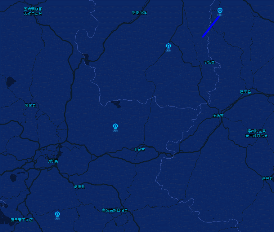
结果如下:
官方文档: 官方文档入口
本人属于刚入行的小菜鸟,如有错误的地方,欢迎指正。