1984-2019年烧伤严重程度监测趋势(MTBS)
烧伤严重程度监测趋势(MTBS)是一个机构间计划,其目标是持续绘制1984年至今美国所有土地上的大火烧伤严重程度和范围。这包括美国西部1000英亩或以上的所有火灾和美国东部500英亩或以上的火灾。覆盖范围包括美国大陆、阿拉斯加、夏威夷和波多黎各。前言 – 人工智能教程
该计划由美国地质调查局地球资源观测和科学中心(EROS)和美国农业部林业局地理空间技术和应用中心(GTAC)进行。
这套资料中包括的两个数据集包括
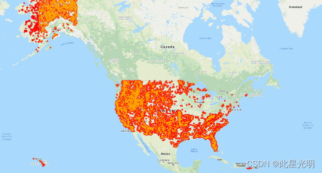
火灾发生地点数据集是一个矢量点ESRI形状文件,包括目前发生在美国大陆、阿拉斯加、夏威夷和波多黎各的所有已完成的MTBS火灾的中心点。
烧毁区域边界数据集是一个矢量多边形ESRI形状文件,包括美国大陆、阿拉斯加、夏威夷和波多黎各所有目前完成的MTBS火灾的烧毁区域范围。
你可以在这里阅读MTBS的概述文件https://www.mtbs.gov/sites/default/files/inline-files/Eidenshink-final.pdf
在MTBS项目中(来自FAQ页面),"烧毁严重程度 "特指火灾对地上生物量的影响。该定义来自于参考文献:NWCG野地火灾术语词汇表》,并以 "火灾严重程度 "为基础,其定义为"一个地方被火改变或破坏的程度;宽泛地说,是火强度和停留时间的产物。"
以下的补充说明进一步澄清了本项目所开发产品的性质:
烧伤严重程度是一个生长季节内产生的一阶效应和二阶效应的综合。
燃烧严重程度主要与生物质和非生物质的可见变化、火灾副产品(烧焦、烧焦、灰烬)和土壤暴露有关。
燃烧的严重性是在一个梯度或顺序的尺度上发生的。
燃烧的严重性是发生在火灾周边的各种影响的组合。
更长期的影响是由火灾后演变的变量控制的,超出了本计划的范围。
烧伤的严重程度是可以测绘的,遥感数据提供了一个测量框架。
区域发生层现在是GEE官方目录的一部分,你可以在这里找到它https://developers.google.com/earth-engine/datasets/catalog/USFS_GTAC_MTBS_burned_area_boundaries_v1
论文引证
Eidenshink, Jeff, Brian Schwind, Ken Brewer, Zhi-Liang Zhu, Brad Quayle, and Stephen Howard. "
A project for monitoring trends in burn severity." Fire ecology 3, no. 1 (2007): 3-21.
MTBS Citation Target Reference Example
| Citation Target | Reference | Example |
|---|---|---|
| General information from MTBS project website | Webpage Title. (revision date). MTBS Project Homepage. Available online: URL [Access Date]. | Monitoring Trends in Burn Severity. (2017, July - last revised). [MTBS Project Homepage, USDA Forest Service/U.S. Geological Survey]. Available online:http://mtbs.gov/[2017, July12] |
| MTBS geospatial datasets | Webpage Title: Data product. (revision date). Agencies. Available online: URL [Access Date]. | MTBS Data Access: Fire Level Geospatial Data. (2017, July - last revised). MTBS Project (USDA Forest Service/U.S. Geological Survey). Available online: Direct Download | MTBS [2017, July12] |
| MTBS project reports | Report compiler. Publication date. Report title. Available online: URL. | Schwind, B. (compiler). 2008. Monitoring Trends in Burn Severity: Report on the PNW & PSW Fires—1984 to 2005. Available online: Home | MTBS. |

Earth Engine Snippet
var area_boundaries = ee.FeatureCollection("projects/sat-io/open-datasets/MTBS/burned_area_boundaries");
var fire_occurrence = ee.FeatureCollection("projects/sat-io/open-datasets/MTBS/fire_occurrence");
License
MTBS data are freely available to the public (similar to a CC0 license) and are generated by leveraging other national programs including the Landsat satellite program, jointly developed and managed by the USGS and NASA. Landsat data are analyzed through a standardized and consistent methodology, generating products at a 30 meter resolution dating back to 1984.
Created by: U.S. Geological Survey Center for Earth Resources Observation and Science (EROS) and the USDA Forest Service Geospatial Technology and Applications Center (GTAC)
Curated by: Samapriya Roy
Keywords: burned area,fire occurrence, fire area, burn severity,MTBS, EROS, GTAC, USGS, USDA
Last updated: 2021-09-05