最近在学习 Android 地图相关的知识,无意间找到了一个非常好的开源项目,特此分享。
项目地址:http://code.google.com/p/big-planet-tracks/
注:上面网站中的程序编译可能会出错,特上传一份成功编译的源码。
Big Planet Tracks
Big Planet Tracks is an online/offline maps application that can import, export and record your GPS tracks, and shows live/real-time statistics such as time, speed, distance, and elevation.
For more information, please see the changelog, copyright and license.
Features
- Maps Usage
- Online maps (Network needed)
- Offline maps (SQLite database created by using Mobile Atlas Creator 1.7 or 1.8)
- Change different SQLite database maps dynamically (e.g. Taiwan.sqlitedb, Japan.sqlitedb, and so on.)
- Map zoom in/out
- Go to my location (i.e. auto-follow the GPS locations) on the map
- Search (Network needed)
- Bookmarks
- Adjust map offset (mainly solve the map shift issue in China)
- Reference scale on the map
- Keep the screen on when viewing the map
- Orange arrow for indicating the phone's direction using the magnetic heading function from source code of MyTracks
- Map magnifications (including 1.5x, 2.0x, 2.5x, 3.0x levels)
- GPS Tracks Management
- Import GPS track files (.gpx) into the database
- Record GPS track and display on the map simultaneously
- Export GPS track to a file (.gpx)
- Show a GPS track's time, distance, average speed, maximum speed and number of waypoints
- Full support all timezones, show the correct GMT time of GPS tracks
- Display the loaded track and the recording track on the map simultaneously
- Enable the background service when recording a track
- Full support for different screen resolutions of the mobile phones
HowTo
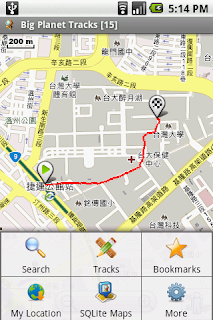
Screenshots
 |
 |
| About | Menu |
|---|
 |
 |
 |
| Start Recording Button | Notification: Recording your track | Stop Recording Button |
|---|
 |
 |
 |
| Import Tracks | Browse Tracks | View Track Statistics |
|---|
更多Android开源地图应用请参考: http://wiki.openstreetmap.org/wiki/Android