数据处理中,经常需要将Excel中的相关属性关联到空间数据中。而Excel中的数据格式较自由,有时候Excel表中的数据包含换行符等特殊符号,而这种包含换行符的数据关联到ArcGIS的属性表中时,在属性表界面中,该界面是不支持换行符的。
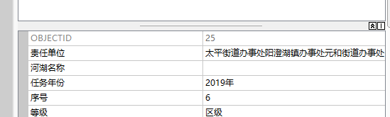
比如下述两条示例数据,显示责任单位为太平街道办事处

当打开编辑模式时,并双击进该属性时,则显示为

此时,在Attributes窗口中,显示为
而平时数据处理时,有时候只是为了查看一下数据的属性,并不会打开编辑模式,也并不一定会点击到该属性。因此,往往会将这种属性只按“太平街道办事处”来处理。
工作中,有时候需要将其他业务数据库中用户填报的信息关联到空间数据中,当用户填报的数据中包含备注等字数比较多的字段时,用户往往是将其他文档整段的内容复制过来,也会产生这种问题。
上述问题解决比较麻烦,首先,数据中这种换行符问题比较难以发现,其次,即使发现了,这种换行符由于在ArcGIS 里是不显示的,也很难删除,直接在ArcGIS的属性窗口中,往往是看似删除了,实际没有删除,为了解决这个问题,往往需要在记事本中把上述内容抄写一遍,再复制到该字段中。
为了解决这个问题,制作了一个ArcGIS插件,通过对图层中的所有的字符类型的字段进行遍历,并将常见的这种特殊类型的字符,替换成其他字符。
插件下载地址:
链接:https://pan.baidu.com/s/1yUOVQ8ZoWngyEO0aRa6dhg
提取码:ssr9
注意:请下载v1.0.9版本,工具条最后一个按钮。工具名称:DayDreamInGIS工具
主要界面:

代码如下
界面部分:
<Window x:Class="WaterAssisterToolbar.AttrSpecialStrRemove.RemoveAttrSpecialStrFrm"
             xmlns="http://schemas.microsoft.com/winfx/2006/xaml/presentation"
             xmlns:x="http://schemas.microsoft.com/winfx/2006/xaml"
             xmlns:mc="http://schemas.openxmlformats.org/markup-compatibility/2006"
             xmlns:d="http://schemas.microsoft.com/expression/blend/2008"
             mc:Ignorable="d"
             Title="设置-移除特殊字符"
        ResizeMode="NoResize"
             Height="300" Width="300" MaxWidth="300" MaxHeight="300">
    <Grid Name="RootGrid">
        <Label Content="图层" HorizontalAlignment="Left" Margin="12,8,0,0" VerticalAlignment="Top"/>
        <ComboBox Name="cmbLayer" HorizontalAlignment="Left" Margin="51,10,0,0" VerticalAlignment="Top" Width="229" SelectionChanged="cmbLayer_SelectionChanged"/>
        <GroupBox Header="待移除特殊字符" HorizontalAlignment="Left" Margin="12,41,0,0" VerticalAlignment="Top" Height="101" Width="268" Name="ToBeRemovedGroup">
            <Grid Height="90" Margin="0,0,0.2,-0.4" VerticalAlignment="Top">
                <CheckBox Name="chkEnter" IsChecked="True"  Content="换行符 \r\n" HorizontalAlignment="Left" Margin="10,10,0,0" VerticalAlignment="Top"/>
                <CheckBox Name="chkA" Content="响铃 \a" IsChecked="True" HorizontalAlignment="Left" Margin="142,10,0,0" VerticalAlignment="Top" RenderTransformOrigin="-0.313,0.526"/>
                <CheckBox Name="chkF" IsChecked="True"  Content="换页 \f" HorizontalAlignment="Left" Margin="10,34,0,0" VerticalAlignment="Top"/>
                <CheckBox Name="chkT" IsChecked="True"  Content="水平制表 \t" HorizontalAlignment="Left" Margin="142,34,0,0" VerticalAlignment="Top"/>
                <CheckBox Name="chkV" IsChecked="True"  Content="垂直制表 \v" HorizontalAlignment="Left" Margin="142,58,0,0" VerticalAlignment="Top" Checked="chkV_Checked"/>

            </Grid>
        </GroupBox>
        <Label Content="替换为" HorizontalAlignment="Left" Margin="12,151,0,0" VerticalAlignment="Top" RenderTransformOrigin="-0.155,0.477"/>
        <TextBox HorizontalAlignment="Left" Name="txtReplace" Height="23" Margin="64,151,0,0" TextWrapping="Wrap" Text="、" VerticalAlignment="Top" Width="216"/>
        <Button Content="确定" Name="btnOK" HorizontalAlignment="Left" Margin="49,220,0,0" VerticalAlignment="Top" Width="83" Height="30" Click="btnOK_Click"/>
        <Button Content="取消" Name="btnCancel" HorizontalAlignment="Left" Margin="174,220,0,0" VerticalAlignment="Top" Width="83" RenderTransformOrigin="-0.557,1.094" Height="30" Click="btnCancel_Click"/>
        <CheckBox Content="处理TOC中所有图层" Name="chkAll" HorizontalAlignment="Left" Margin="51,193,0,0" VerticalAlignment="Top"/>

    </Grid>
</Window>
界面部分代码:
using System;
using System.Collections.Generic;
using System.Linq;
using System.Text;
using System.Threading.Tasks;
using System.Windows;
using System.Windows.Controls;
using System.Windows.Data;
using System.Windows.Documents;
using System.Windows.Input;
using System.Windows.Media;
using System.Windows.Media.Imaging;
using System.Windows.Navigation;
using System.Windows.Shapes;
using ESRI.ArcGIS.Carto;
using ESRI.ArcGIS.Geodatabase;
using ESRI.ArcGIS.Geometry;

namespace Toolbar.AttrSpecialStrRemove
{
    /// <summary>
    /// RemoveAttrSpecialStrFrm.xaml 的交互逻辑
    /// </summary>
    public partial class RemoveAttrSpecialStrFrm : Window
    {
        private IMap pMap = null;

        private IFeatureLayer pftlyr = null;

        public IFeatureLayer Pftlyr
        {
            get { return pftlyr; }
            set { pftlyr = value; }
        }
        private char[] specialCharArray;

        private bool isAll = false;

        public bool IsAll
        {
            get { return isAll; }
            set { isAll = value; }
        }

        private List<char> special_char;

        public List<char> Special_char
        {
            get { return special_char; }
            set { special_char = value; }
        }

        private string replace_str;

        public string Replace_str
        {
            get { return replace_str; }
            set { replace_str = value; }
        }

        public RemoveAttrSpecialStrFrm()
        {
            InitializeComponent();
            special_char = new List<char>();
            pMap = ArcMap.Document.FocusMap;
            GISCommonHelper.CartoLyrHelper.setFeatureLyrCombox(ref cmbLayer, pMap, esriGeometryType.esriGeometryAny);
        }

        private void chkV_Checked(object sender, RoutedEventArgs e)
        {

        }

        private void btnOK_Click(object sender, RoutedEventArgs e)
        {
            replace_str = txtReplace.Text;
            isAll = chkAll.IsChecked.Value;

            if (chkA.IsChecked.Value)
            {
                special_char.Add('\a');
            }

            if (chkEnter.IsChecked.Value)
            {
                special_char.Add('\r');
                special_char.Add('\n');
            }

            if (chkF.IsChecked.Value)
            {
                special_char.Add('\f');
            }

            if (chkT.IsChecked.Value)
            {
                special_char.Add('\t');
            }

            if (chkV.IsChecked.Value)
            {
                special_char.Add('\v');
            }

            this.DialogResult = true;
        }

        private void btnCancel_Click(object sender, RoutedEventArgs e)
        {
            this.DialogResult = false;
        }

        private void cmbLayer_SelectionChanged(object sender, SelectionChangedEventArgs e)
        {
            if (cmbLayer.SelectedIndex > -1)
            {
                pftlyr = cmbLayer.SelectedValue as IFeatureLayer;
            }
        }
    }
}
核心代码:
using System;
using System.Collections.Generic;
using System.Text;
using System.IO;
using ESRI.ArcGIS.Carto;
using ESRI.ArcGIS.Geodatabase;
using ESRI.ArcGIS.Geometry;
using System.Windows.Forms;


namespace Toolbar.AttrSpecialStrRemove
{
    /// <summary>
    /// 移除换行符等特殊字符
    /// </summary>
    public class btnRemoveAttrSpecialStr : ESRI.ArcGIS.Desktop.AddIns.Button
    {
        public btnRemoveAttrSpecialStr()
        {
        }

        private List<char> special_char_list;
        private string replacestr=";";

        int cnt = 0;

        protected override void OnClick()
        {
            try
            {
                RemoveAttrSpecialStrFrm ras = new RemoveAttrSpecialStrFrm();
                if (ras.ShowDialog() == true)
                {
                    cnt = 0;
                    special_char_list = ras.Special_char;
                    replacestr = ras.Replace_str;

                    if (ras.IsAll)
                    {
                        List<IFeatureLayer> ftlyrlist=GISCommonHelper.CartoLyrHelper.getAllLayer<IFeatureLayer>(ArcMap.Document.FocusMap);
                        ftlyrlist.ForEach(p => {
                            Execute_specialStr_Remove(p);
                        });
                    }
                    else
                    {
                        Execute_specialStr_Remove(ras.Pftlyr);
                    }

                    MessageBox.Show("处理完成");
                }
            }
            catch (Exception ex)
            {
                MessageBox.Show("发生未知异常:"+ex.Message);
            }

        }

        /// <summary>
        /// 遍历要素,替换要素各字段中的特殊字符
        /// </summary>
        /// <param name="pftlyr"></param>
        /// <returns></returns>
        private int Execute_specialStr_Remove(IFeatureLayer pftlyr)
        {
            int cnt = 0;
            IWorkspaceEdit pwsEdit = (pftlyr.FeatureClass as IDataset).Workspace as IWorkspaceEdit;
            pwsEdit.StartEditing(false);
            pwsEdit.StartEditOperation();

            IFeatureCursor pftcursor = pftlyr.FeatureClass.Update(null, true);
            IFeature pFeature = pftcursor.NextFeature();

            while (pFeature != null)
            {
                System.Diagnostics.Debug.WriteLine(pFeature.OID);

                remove_feature_attr_specialStr(ref pFeature);
                pftcursor.UpdateFeature(pFeature);
                pFeature = pftcursor.NextFeature();
            }
            pwsEdit.StopEditOperation();
            pwsEdit.StopEditing(true);

            return cnt;
        }

        /// <summary>
        /// 替换要素所有字段中的特殊字符
        /// </summary>
        /// <param name="pFeature"></param>
        private void remove_feature_attr_specialStr(ref IFeature pFeature)
        {
            for (int i = 0; i < pFeature.Fields.FieldCount; i++)
            {
                IField pfd = pFeature.Fields.get_Field(i);
                if (pfd.Type == esriFieldType.esriFieldTypeString)
                {
                    //只处理字符类型的值
                    string val = pFeature.get_Value(i).ToString();
                    string val_r = remove_specialStrInString(val);
                    if (!string.Equals(val, val_r))
                    {
                        pFeature.set_Value(i, val_r);
                    }
                }
            }
        }

        /// <summary>
        /// 替换字符串中的特殊字符
        /// </summary>
        /// <param name="str"></param>
        /// <returns></returns>
        private string remove_specialStrInString(string str)
        {
            special_char_list.ForEach(p => {
                str=str.Replace(p.ToString(), replacestr);
            });

            return str;
        }

        protected override void OnUpdate()
        {
        }
    }
}
